Kenya has increasingly turned to unmanned aerial vehicles (UAVs) and drone-enabled technologies to bolster wildlife protection, reduce poaching, and strengthen ecosystem monitoring. These initiatives are led by government agencies like Kenya Wildlife Service (KWS), conservation NGOs, and collaborations with research partners, leveraging thermal imaging, AI, and remote-sensing innovations.
1. Maasai Mara Wildlife Monitoring via Drones
In April 2022, the Mara Elephant Project (MEP) resumed drone operations in the Maasai Mara, deploying UAVs operated by trained rangers to support elephant protection and human‑wildlife conflict mitigation. Rangers now carry drones on routine patrols to deter elephant incursions—where the drone’s buzzing sound typically encourages the animals to avoid farmland. These systems also serve broader reconnaissance needs: conducting aerial census work, collecting population data, and aiding veterinary teams during wildlife interventions. Ranger teams received six-day training courses covering air law, flight planning, meteorology, and safety protocols—after which remote‑pilot licensing was granted by Kenya’s aviation authorities.
2. Ol Pejeta and Solio Reserve: Regulatory Clearance for Anti-Poaching Drones
In mid‑2023, Ol Pejeta Conservancy secured formal approval to fly surveillance drones across its property under the “Aerial Ranger” program. This marked Kenya’s first fully regulated drone-based anti-poaching initiative managed by park authorities. Fleet operations commenced in June, using thermal and visual sensors to detect human movement and coordinate ranger responses.
Meanwhile, Solio Game Reserve, along with Lake Nakuru National Park and Ol Pejeta, rolled out FLIR-based AI-integrated thermal cameras as part of the Kifaru Rising project—supported by WWF and the U.S. State Department. These sensors detect human or vehicle intrusion at night and send automated alerts to ranger command centers, bolstering nighttime surveillance and rapidly curbing poaching incidents.
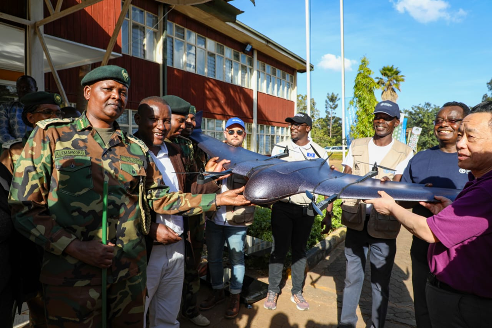
3. WildDrone AI & Hackathon Demonstrations
In early 2025, the EU-funded WildDrone project hosted its first drone‑AI hackathon at Ol Pejeta. Over 280 flight missions were conducted, including Beyond Visual Line of Sight (BVLOS) nighttime flights using thermal cameras to track species like rhinos and elephants. The event brought together wildlife scientists, engineers and Kenyan partners to test autonomous UAV designs, low‑disturbance platforms, and aerial monitoring systems. The project demonstrated how AI-powered drones could collect extensive real-time wildlife data, improve census accuracy, and reduce the need for ground patrols.
4. Computational Conservation Tools & AI-Driven Tracking
Recent research from Kenyan consorts has produced WildLive, an onboard image processing system enabling near real‑time detection and tracking of multiple animals during flight using onboard AI (YOLO). Tested at Ol Pejeta, the system tracks animal movement with high frame rates and precision, supporting autonomous drone missions over conservation areas. Similarly, the MMLA dataset of drone footage from Kenyan reserves supports development of species detection algorithms across multiple environments and animal types. These technologies enhance automated ecological monitoring, reduce required human airtime, and improve decision support for park management.
5. Kenya Wildlife Service (KWS) Tech Integration Goals
While drones are not yet widely available across all parks, KWS is adopting aerial tools for both conservation and security roles. In Taita Taveta, community rangers deployed an EarthRanger platform on mobile devices across conservancies to plot wildlife movements and direct rapid response—including alerting rangers to potential conflict zones. Though reliance on satellite and ground data remains strong, drone imagery is expected to feed into this broader system. Government agencies are also exploring equipping aerial surveillance units to map wildlife and human activity, based on lessons from advanced parks.
6. Multi-Stakeholder Coordination and Community Impact
NGOs such as the Sheldrick Wildlife Trust, WildDrone, and Mara Elephant Project are collaborating with KWS to integrate drones into holistic conservation strategies. Sheldrick’s aerial component supports wildlife rescue, aerial search during orphan elephant retrieval, medevac missions, and security patrol co‑ordination—though many flights are pilot‑guided rather than fully autonomous. These operations have accelerated deployments in remote ecosystems and supported ground-based canine units and ranger deployments.
The expansion of drone projects has brought related social benefits: community rangers gain technical skills and new career exposure; monitoring technologies support trust between wildlife authorities and local communities; and reduced poaching incidents build public confidence in conservation programming.
7. Operational and Ecological Outcomes
Reduction of poaching incidents: Thermal and AI-enabled sensors have drastically lowered rhinoceros poaching in key sanctuaries and disrupted illegal activity near boundaries.
Enhanced ranger efficiency: Drones allow over‑flight of vast areas faster and safer than mounted patrols, particularly overnight.
Ecological monitoring: Aerial surveys and AI tracking systems support behavioral and genetic research, population mapping, and identification of ecological threats like habitat degradation.
Human–wildlife conflict mitigation: Drones frequently guide elephant herds away from agricultural areas, reducing crop damage and increasing community safety.
8. Key Takeaways by Mid‑2025
Kenya’s drone and aerial tech ecosystem post‑2022 has progressed along three key axes:
1. Legal and operational approval for drone flights over conservancies (Ol Pejeta, Solio).
2. AI‑powered sensor deployment in rhino sanctuaries to enable real-time intrusion alerts and anti‑poaching interventions.
3. Emerging research and autonomy capabilities for automated wildlife detection and tracking via onboard AI systems derived from datasets collected in Kenyan reserves.
These systems directly support Kenya’s goals of zero poaching, expanded ecological surveillance, and safer human‑wildlife interactions.

